Waterfront: Difference between revisions
From Halopedia, the Halo wiki
mNo edit summary |
m (replaced outdated pre-alpha image.) |
||
| Line 3: | Line 3: | ||
{{Multiplayer Map Infobox | {{Multiplayer Map Infobox | ||
|name=Waterfront | |name=Waterfront | ||
|image=[[File: | |image=[[File:WaterfrontView.jpg|300px]] | ||
|game=''[[Halo: Reach]]'' | |game=''[[Halo: Reach]]'' | ||
|location=Viery Territory, Reach | |location=Viery Territory, Reach | ||
| Line 37: | Line 37: | ||
File:HunterFirefight.jpg|A Spartan fighting a Hunter on the map. | File:HunterFirefight.jpg|A Spartan fighting a Hunter on the map. | ||
File:WATERFRONT.jpg|A heatmap of Waterfront. | File:WATERFRONT.jpg|A heatmap of Waterfront. | ||
File:Reach Waterfront.jpg|A Pre-Alpha image of the map. | |||
</gallery> | </gallery> | ||
Revision as of 05:44, August 17, 2011
Template:Ratings Template:Multiplayer Map Infobox
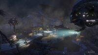
Waterfront is a Firefight map in Halo: Reach.[1] It is set at night, in a pumping station beside a body of water near the Ütközet dam in the Viery Territory. The map is based on a section of the campaign level Nightfall.
Overview
Waterfront is a medium-small sized, industrial themed Firefight map. The map contains a series of buildings positioned in a circular pattern around a central opening with several ramps leading down to the water basins where the Covenant are usually dropped down. The complex is connected to the land by a covered bridge which offers great protection from airborne enemy fire. Phantom dropships drop off waves of enemies in a 360 degree circle around the map, which forces players to defend the middle buildings more. The main hazards on this map are the Jackal snipers on the hill.
Locations
The following are known locations on the map that are so named on the player's heads-up display during gameplay:
- Circle
- Gully
- Shed
- House
- Beach
- Pump
- Tunnel
Gallery

A Spartan aiming a Target Locator at a Phantom on Waterfront.

A match of Generator Defense.

A Spartan fighting a Hunter on the map.
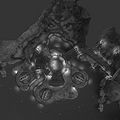
A heatmap of Waterfront.
A Pre-Alpha image of the map.


Sources


