Liwitoni: Difference between revisions
From Halopedia, the Halo wiki
CMDR RileySV (talk | contribs) (Added an image and some info.) |
CMDR RileySV (talk | contribs) (Moved a bit of trivia from the Liwitoni station page.) |
||
| Line 5: | Line 5: | ||
==History== | ==History== | ||
During the [[Battle of Mombasa]], the area directly northwest of the district was [[Glassing|glassed]] by a {{Class|CAS|assault carrier}}.{{Ref/Level|Halo 3: ODST|Coastal Highway}} | During the [[Battle of Mombasa]], the area directly northwest of the district was [[Glassing|glassed]] by a {{Class|CAS|assault carrier}}.{{Ref/Level|Halo 3: ODST|Coastal Highway}} | ||
==Trivia== | |||
In modern-day [[Wikipedia:Mombasa|Mombasa]], there is a district called "Liwatoni". This location is fully submerged by the 26th century, located some hundreds of meters WNW of [[Uplift Nature Reserve]]. Evidently, the district has been redesignated since the 21st century; this is the case with many other districts in the city as well, due to the fact that the coastlines and structure of the city have changed so dramatically. | |||
==List of appearances== | ==List of appearances== | ||
Revision as of 18:37, November 3, 2021
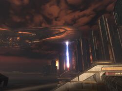
Liwitoni was a district located on Mombasa Island in the city of New Mombasa, Kenya. This district held a Vyrant Telecom tower[1] and presumably Liwitoni Station.
History
During the Battle of Mombasa, the area directly northwest of the district was glassed by a CAS-class assault carrier.[2]
Trivia
In modern-day Mombasa, there is a district called "Liwatoni". This location is fully submerged by the 26th century, located some hundreds of meters WNW of Uplift Nature Reserve. Evidently, the district has been redesignated since the 21st century; this is the case with many other districts in the city as well, due to the fact that the coastlines and structure of the city have changed so dramatically.
List of appearances
- Halo 2 (First appearance)
- Halo 3: ODST
Sources
- ^ Halo: The Essential Visual Guide, page 129
- ^ Halo 3: ODST, campaign level Coastal Highway
| ||||||||||||||||||||||||||||||||
